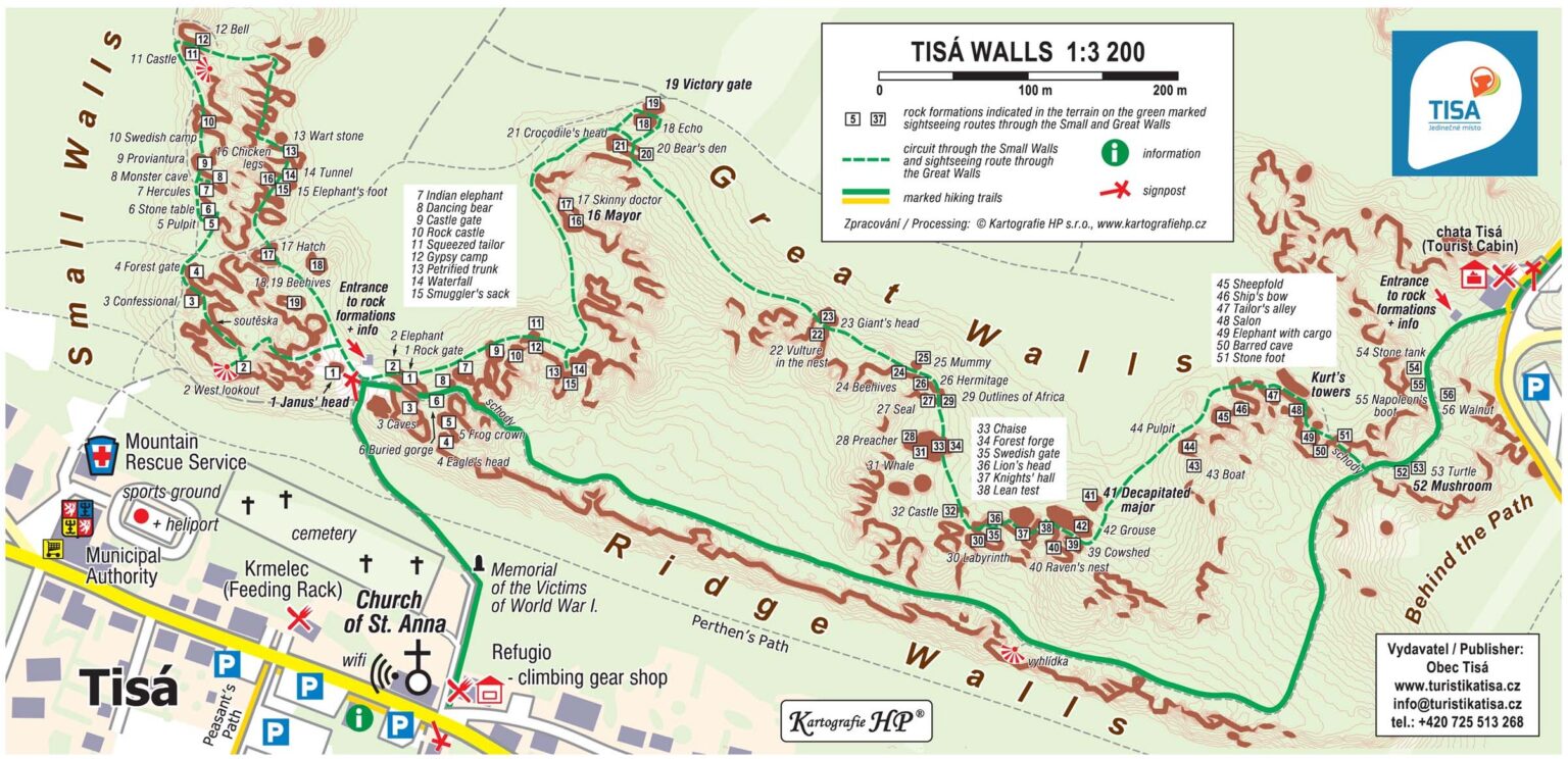
Tisá Walls
Guide
You can find a guide – trip through the Little and Great Walls within the section “Hiking Trips”.
Interactive map
You can open the map at mapy.cz and save it in your backpack.
Tisá Walls are a part of the Elbe Sandstone Mountains Natural Preserve, which represents a part of a sandstone plateau created approx. 90 million years ago during the Cretaceous Period of the Mesozoic era.
After the sea, which was present here at that time, receded it left layers of sedimented sandstone fortified by various cements behind. As time went by the earth moved and caused the cracking of these sediments. Gradual weathering, erosion, the effect of water, and material loss caused the origination of this richly articulated landscape with deep canyons with vertical walls of various forms that already bear a name in many cases.
Tisá Walls are a natural preserve - a bizarre rock town located at the southern edge of the Iron Mountain’s fault of the Mesozoic sandstone plateau. Together with Rájec Walls, Ostrov Walls and Vysoký Sněžník they create an attractive tourist and rock climbing area in the western headland of the Elbe Sandstone Mountains Natural Preserve. The sandstone massif of Tisá Walls, reaching up to 613 m above sea level, falls southwards in an almost monolithic vertical barrier, where it was disturbed on the northern side by erosive denundation processes into numerous columns, pillars, towers, walls, ravines, overhangs, caves, courts and mushroom rocks.
Tisá Walls belong to the oldest tourist areas in the Elbe Sandstone Mountains.
We can read about this location in a guide around Děčín estate dated back to 1828, where we can find even one of the oldest depictions of the local rocks - the formations of the Doctor (Doktor) and the Mayor (Starosta). In order to visit the rock town in the past they used to recommend taking a guide, who would point out the rock formations spurring the visitors’ imagination. The tradition in naming the rocks has been kept ever since and the names of the most known formations remained in use.
Tisá Walls divide into two large parts - GREAT AND LITTLE WALLS (Velké a Malé stěny) - with sightseeing trails leading through both these parts, which are also interconnected by a nature trail marked with a white square with a diagonal green stripe offering 7 informative stops. There is also a red marked tourist trail leading across the range of the Great Walls, which is the shortest connection between the entrance area and the eastern end of the rock town at the Tourist Cabin (Turistická chata).
Tisá Walls
Bürschlické Walls
Interactive map
You can open the map at mapy.cz and save it in your backpack.
A long barrier of sandstone rocks located north of Tisá rock town.
It starts at the road Tisá – Rájec at a place with Klement’s Cross (Klementův kříž). This place used to be called Schaafschlichte in the past, because people used to graze sheep in the valley along the rocks. You can find the ruined remains of a huge rock tower right at the path on the western edge of the massif.
Neuber’s Tower collapsed and broke into several parts on the 5th of December 1981 due to climatic influences and erosion. The collapse of the tower was felt by the inhabitants of Tisá as a small earthquake.
This area is popular both among the rock climbers and common tourists, who can walk among the Bürschlické Walls and Tisá Walls or take a direct path through Bürschlické Walls up to the Tourist Cabin (Turistická chata) or continue on one of the circuits in Tisá Walls.
Bürschlické Walls
Rájec Walls
Interactive map
You can open the map at mapy.cz and save it in your backpack.
If you visit Rájec, you will truly feel as if you were in paradise.
The name of the settlement would fit perfectly (ráj = paradise), however, it comes from German Raiza, Ratze, therefore its name comes from the ever-present plant – heather. This is a slightly forgotten and more secluded area. There are protected wetlands with rare flowers here. The former inhabitants in the Northern Germany used to breed sheep called “Heidschnucke” – “wetlands lover”.
This breed of sheep was able to graze on the local wetlands growth. The low-lands sheep could not withstand local winters.
The area is popular among rock climbers, who love local large massifs, smaller towers, and most importantly the local serenity. The area is divided into three smaller areas based on the rock massifs – Ptačí Walls, Rájec Valley and Ostříží Walls. You will find the most serenity in the first area and the tallest towers in the second one.
Even common tourists will like it here,
as aside from the aforementioned rock areas they can visit interesting historic places, the nature preserve of Olšovksý stream’s wolds, or the abandoned settlements.
The section “Hiking Trips” contains the description of a trail, where you can visit the abandoned settlements of Rájec at the state border, Nové Dvory, and Hladov, two mills, a chapel, a memorable linden tree, and the nature preserve of Olšovksý stream’s wolds. It is an undemanding trail approx. 7 km long, taking you through paths and meadows (partly on German side).
Průvodce
The time of the year suitable for hiking trips – the beginning of spring, the end of fall.
Rájec Walls
Ostrov Walls
Interactive map
You can open the map at mapy.cz and save it in your backpack.
Ostrov is a settlement northwards from Tisá located at the end of a long valley called “Bielatal”.
The German name of the settlement – Eiland – comes from the old Phrygian name for a land surrounded by water. A picturesque valley with five water surfaces flanked by high sandstone rocks, which represents an important rock climbing area.
Both rock climbers and common hikers, who can visit the historic and nature landmarks, will like their visit in Ostrov.
Ostrov used to be a local industrial zone of sorts in as early as the 16th and 17th century. There used to be iron-mills, forge shops, saw-mills, grain-mills, and nearby stone pits here, while both the fields and meadows were used for farming.
The way we see it today, fief granting, liberties and obligations safeguarded both the commerce and the tax liabilities. Because it was possible to document many handouts and materials, we recommend a walk through the history of the place. You can find a guide in the section “Hiking Trips” - the 5 km long circuit trail will help you visit places, where there used to be mills, taverns, some landmarks – commemorative crosses, historical municipal border stones, and the spring which Countess of Thun used to have water brought from.
If you walk from Ostrov following the red mark to the Tourist Cabin in Tisá, at the place, where the path leads steeply uphill, there is a small rock town called Himmelreich (Sky Realm).
The path is lined with massive rock towers. This area received its name after the fact that when you are walking uphill, you will only see the sky among the rock tops and trees. The upper part, close to the path, accommodates a monument devoted to the rock climbers from our region that died in the mountains. It was exhibited in 2015.
Průvodce
Procházku historií Ostrova naleznete v sekci pěší výlety.
Ostrov Walls
Above the walls – Modřín
Interactive map
You can open the map at mapy.cz and save it in your backpack.
A high rock barrier extending from the eastern end of Tisá village almost up to the settlement of Sněžník,
which perks above the Libouchecký stream’s valley above the municipalities of Libouchec, Kamenec, Modrá and Jílové. Right at the beginning of the sandstone wall there stands a vista point – a tall rock spike called the Bandog Tower (Věž Dogy). It used to be called Zsigmondturm (Zsigmond’s Tower) after a distinguished alpine rock climber, who died young in the mountains.
In the past it also used to be called Swedish Patrol (Švédská stráž).
According to legends from the Thirty Years’ War the Swedes were supposed to have a patrol lookout here, who would warn them about the approaching imperial army. Approximately in the middle of the massif, there lies Rajská Tower, the highest formation of the whole area. Above the wall, close to Sněžník settlement, there used to be a rather large deer game preserve.
Deer game imported from abroad was fed extra side products from Schicht’s soap factory in Ústí nad Labem. That is why this popular household product was called “Mýdlo s jelenem” (soap with a deer). The game prospered and local stags could boast branched antlers, which were awarded prizes at various competitions. Later, however, all these trophies were annulled because of the artificial additional feeding. You can find a trip in the area among the suggestions for hiking trips.
There used to be a small settlement called Havraní underneath the walls until 1950. The place of the former roadside inn, shrouded in many legends, seems as if it has been abandoned just recently – a tool cellar, a well, a niche. There are traces of rock quarrying and mining activities in the slope underneath the walls.